
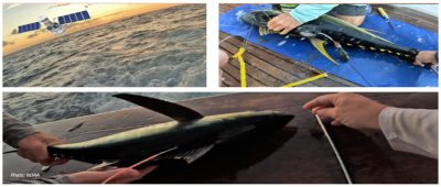
USA: NOAA Fisheries scientists, Derke Snodgrass and Eric Orbesen, ventured to the southern Caribbean in February to satellite tag highly migratory species around the waters of Curaçao. They focused on satellite tagging to capture data that will add to our growing knowledge on yellowfin tuna habitat use and movement patterns.
Since 2010, our center has deployed more than 100 satellite tags on yellowfin tuna throughout the Gulf of Mexico, Caribbean, and Northwest Atlantic waters. These tags record depth (pressure), temperature, light level every 3 seconds (used to estimate geolocation). They transmit summarized sets of data via the Argos satellite system after the tag detaches from the fish (approximately 240 days later). This team wanted to fill in data gaps that were most prominent around Curaçao.
Curaçao is a small Island located in the southern part of the Caribbean Sea. A network of Fish Aggregating Devices attract billfish and tuna to the area, and local fishermen often move between these FADs to locate fish. While many yellowfin tunas are captured in this area, so far none of our previously tagged fish have ventured near Curaçao. To understand how spatial movement patterns vary over the species’ range, it is essential to monitor fish in as many diverse locations as possible. The data the team gathered from fish tagged in this geographic region will help scientists close the knowledge gap on movements of yellowfin tuna in the Western Atlantic.
Satellite tags are amazing tools for providing information not only on where fish move throughout an area, but also on how fish use different parts of the water column. Our primary objectives for studying oceanic and coastal pelagic species by satellite are to obtain information on:
By attaching satellite tags to these heavily targeted fish the team is able to acquire long-term data that assists in the management of these populations. The tagging data are submitted annually to the International Commission for the Conservation of Atlantic Tunas (ICCAT) to inform international stock assessments and are a key component in defining Essential Fish Habitat domestically. The data are also beneficial for estimating post-release mortality rates associated with different types of fishing. Our team used tags from the Cooperative Tagging Center, from University of Maine, and from ICCAT for this project.
This trip took place over the last week of February, when peak fishing activity usually occurs in the region. During the 8-day trip the team was able to get 14 yellowfin tunas tagged that weighed between 40–50 pounds (18-22 kg). They also tagged approximately 50 additional small tunas using traditional spaghetti tags. A variety of tuna species were tagged including skipjack, yellowfin, blackfin, and bigeye. Hopefully some of these fish will be recaptured in coming months or years and reported to us.
One unusual occurrence that happened while the team was on the trip was that one of the tunas that was satellite tagged by our crew was recaptured. Overall, the science retained from the satellite tags will provide a lot of information about tunas in the southern Caribbean region. They will continue to tell us more about these species' habits and migratory patterns, so that we can provide data that directly improves stock assessments. Improved assessments will lead to more effective management of these species by ICCAT in partnership with NOAA Fisheries’ Atlantic Highly Migratory Species Management Division and Southeast Regional Office.
Source: NOAA